“I just wanted to make sure our people hadn’t floated away… but I took a walk around and it looked like everyone was tucked in tight.” ~Wendy S. Walters, “Lonely in America”
When I was abroad, my best friend from home visited me, flying in a week before the program ended. She arrived at my dorm frazzled and mildly discombobulated from a day of travel and navigating a city – and a country – she was unfamiliar with only for me to promptly toss her on a bike and drag her into the city center. As we biked across a canal (a most stereotypical scene for the Netherlands) I listened as she marveled at sights and sounds I had become so familiar with; it was strange, almost, to be looking at the city where I had lived for six months – and was now about to leave – through the eyes of someone seeing it for the first time. I turned to her as we made our way down to the farmer’s market, wanting to describe something about the different routes that could be taken from the dorm to the city center but stopped as I realized that I wouldn’t be able to communicate the true intent behind the comment.
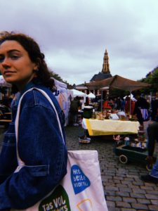
I wanted Wren to be able to see Groningen as I saw it, wanted her to be able to see the way the streets wove together to bring us home and to school and to the park and to the best cafes, wanted her to understand everything in the same direction, the same orientation. But that’s not possible. Wren couldn’t see that space as I saw it because Wren is not me; and vice versa, I could not see the space as Wren saw it because I am not Wren. We were in the same space, but our conceptions of this space were entirely different because our interactions with it were based upon different experiences – different directions and origins and time frames and priorities led to deeply different perspectives.
That everyone’s mental spatial map of a space is different is an idea that seemed obvious once I was aware of it, like the idea that the same colors may look different [find link] to different people or that one food tastes different to different people (à la cilantro). Yet, the awareness of individual spatial perspectives tripped me up a little bit, perhaps because my conception of the space I inhabit is so inherent to the way that I live and function on the day-to-day that I have little reason to question something so seemingly basic. I’ve begun to realize, however, that my perceptions of and interactions with the spaces I inhabit are dictated by engrained socio-structural influences. For example, my whiteness dictates my ability to navigate certain spaces deemed to be “white,” (and, thus, generally more privileged) and has likely dictated my ancestral and current family’s ability to navigate their own worlds, thus further influencing my birth into a privileged, wealthy family living in a wealthy and stable area; my (again, familial) wealth dictates my life in a wealthy suburb of Buffalo, my ability to attend college, my ability to study abroad and interact with spaces beyond my original; my familial stability dictates a rooted sense of home; my abled-ness and my youth dictate my ability to easily physically navigate spaces created for the abled and the young; my femininity dictates my ability or inability to navigate spaces – both public and private – dominated by men. Thus, social and structural factors deeply affect my perception of space, as they shape not only where I live but how I live in this space; however, these social and structural factors are so deeply engrained within my lifestyle, so deeply inherent in my perceptions of which spaces I can and cannot navigate and how I navigate space that my navigation of space seems to be not only naturally occurring but simply not worthy of attention. Additionally, my privilege, in both my whiteness and my wealth allows me to remain relatively unaware of these structural factors as most do not function as a detriment or a limitation but, rather, enable my ability to remain in certain privileged spaces.
If Wren and I – two wealthy, white women, born into the same hometown, growing up in the same school system, with the same people – can have fundamentally different perceptions and perspectives of spaces we both share simply due to separate experiences, how different are other individuals’ perspectives of space, especially when taking into account these socio-structural influences? What are the effects of these individual conceptions? How do they create or influence a communal conception of space?
In her article “Geographies of Pain, Geographies of Pleasure: Black Women in Jim Crow New Orleans,” which is included in Kim Vaz-Deville’s Walking Raddy: The Baby Dolls of New Orleans, LaKisha Michelle Simmons describes the experiences of black women in New Orleans:
“Everyday geographies could be full of physical danger and verbal abuse. White abuse forced black women and girls to think about bodily control within urban geography and the various spaces where they were most likely to expect harassment. This was an embodied experience: ‘of becoming a body in a social space’” (32).
Simmons thus describes how the individual spatial perspectives of black women in New Orleans were (and, indeed, still are) shaped by the societal violence, both physical and otherwise, they experienced. Oftentimes, this violence, which is deeply rooted in hegemonic structures created to repress African Americans, is made structural and forced onto individuals
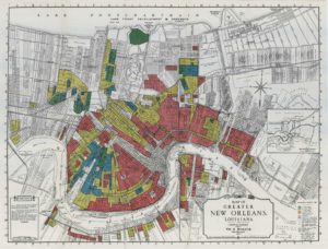
and their spaces through various governmental policies and business practices. We have learned about the many ways that structural violence has been manifested in geography and conceptions of space. These manifestations occur through such policies as redlining – which is the practice of discriminatory lending practices meant to limit African American ability to achieve home ownership (this practice still affects African Americans today); this was often represented through physically outlining in red predominately African American (“at-risk”) neighborhoods on maps.
Oftentimes, the these legal and political manifestations of structural violence are not only reinforced but justified by visual representations of the spaces and geographies upon which these oppressive perspectives are being enforced. In Helen Warfle’s post wherein she talks (just enough) about maps, she makes the point that maps are inherently artistic, as any attempt to represent a physical space and reality on a smaller scale is rooted in interpretation; thus, while maps and art are conceived of as distinct representations of space – due to the seeming differences in their representational purpose, wherein maps are supposedly informational and art is expressional – these representations of space, in fact, interact with and imitate one another. These interactions between informational and expressional representations of space serve to create a certain ambiguity surrounding truth and reality: What aspects of a representation – whether it be explicitly artistic, explicitly geographical, or somewhere in between – are the truth? What is individual interpretation? What is purposeful or subconscious alteration meant to verify actions, impositions, or interpretations of the space?
We’ve seen this ambiguity between art and geography, and how it can be used to reinforce dominant narratives which negatively affect an oppressed people’s ability to navigate their space, in Professor Cope’s analysis of British woodcuts depicting the Irish and their landscape. These woodcuts, created to disseminate information to the English public about the Irish and the English domination of the Irish countryside, warp landscapes and depictions of space in order to justify the imposition of the English upon the Irish space. For example, depictions of the landscape previous to British conquer depict the space as rocky and wild (i.e. untamed, something to be conquered – this leads into an entirely different conversation about anthropological attitudes towards the environment which, for everyone’s sake, I won’t yammer on about); depictions of the landscape after British conquer portray the landscape as gentle, with rolling hills upon which the British can march out their progress-toting armies (more on portrayals and conceptions of progress in Episode 2 of this post).
Another example of colonial representations which reinforced the dominant narrative through depictions of land while marginalizing the local populations and perpetuating structural violence against these populations were called views. Views, in Dutch art (did you forget I studied abroad in the Netherlands?), are bird’s-eye-view-esque depictions of a certain space. Many were created during the peak of Dutch colonialism – which, not coincidentally, coincided with the so-called Dutch Golden Age – in order to represent not only Dutch cities but also areas colonized by the Dutch. These views are lost somewhere in the mire of ambiguity between maps and visual art described by Helen as they are conceived of as art, while their similarity to maps allows for an imitation of truth and alteration of spatial realities. These views portrayed colonized spaces – such as Jakarta (link to a view of Batavia here), which was renamed as Batavia under the Dutch – as inherently Dutch, with Dutch city-scapes, Dutch organization, Dutch ships entering and leaving the ports. This promulgation of images promoting the inherent Dutch-ness of the landscape allowed for the elimination of local narratives, thus perpetuating the Dutch conquering of the land and local populations and allowing for the Dutch removal of local populations from their land (the Dutch were as violent, historically, as other colonizers, massacring colonized populations and building their Golden Age from the slave trade).
Thus, art that explicitly defies these oppressive colonial depictions of space – such as Steve Prince’s Flambeau, which can be clearly seen to be undermining
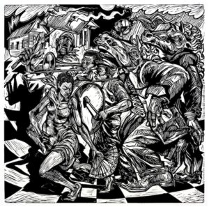
expected perceptions of space in its recursive progression across the page, with the crowd moving right to left (and, thus, in the minds of those educated in a reading system which moves from left to right, such as in the English language, subverting the expected narrative of progression seen in the woodcuts discussed by Professor Cope) – initiates the reclamation of representational space. Reclamation of visual representations of space allows for the development of an awareness of the structural influences upon space. Further, actual reclamation of physical space, such as black women’s physical reclamation of oppressed spaces through dance as described by Simmons in “Geographies of Pain, Geographies of Pleasure” allows for actual subversion of the hegemony imposed upon marginalized spaces. This subversion allows for the creation of individual conceptions of spaces and navigation of space free from the socio-structural influences enacting marginalization. Thus, the reclamation of space allows for marginalized communities to remain rooted and not, in the words of Wendy Walters, “float away” and become lost in a dominated space.